Yes, today is the fifth day of tracking Gypsy. Day one was the release in the Marin Headlands, and roost along the Miwok Trail. Day two Gypsy headed northward to a location northeast of Burdell. Day three, the teams located Gypsy near Manor on private lands. Day four, Gypsy remained on the lands just south of Manor (same location). And, now we are to Day five.
How creative can the teams be??? We are down to just two teams. Barb and Kim, and Maxine and Ruth. Barb hated to put 50% of her resources on Mt. Burdell, so it was decided that the two teams would work the area near Manor, and then move around looking for other good places to take bearings. If they couldn't locate Gypsy, then one team would head up to Burdell so they could survey the whole area.
Sonoma Mt. Rd., Stony Point Rd., Wilson Hill (used many times in prior days) continued to produce bearings, Cinnabar Rd off Petaluma Blvd., Wagner Lane, Meacham Hill, San Antonio Rd., etc. All of these spots were visited by the teams, and they found some very interesting high points, such as the Institute of Noetic Sciences where the team left with balance and inner harmony.
Some of us were using an app called Life360, which keeps track of our location as we move all around. So, even though the teams were moving all over, I could just check in on them to see where they actually were located.
The teams took some pictures during tracking, (and I received some from prior days), so in a few days I will return home, and I will move the pictures over to this blogspot and to our yahoo site, so that everyone can see the trackers hard at work.
So, as we neared the end of day 5, the trackers were showing some fatigue. Same spots day after day, and Gypsy remained on the private land in the area near Manor and Adobe. And, yes there were circling signals, so we knew Gypsy was moving locally. It was decided that there was little new to learn from Gypsy. He has been hanging out on the same spot since Tuesday. Four days of visiting the same spots, and plotting bearings which pointed back to that same spot near Manor and Adobe. So, the tracking was finished. There are several people who were available next week to go out and track, and several of the new apprentices would like to go out again; so, I would suggest that we do some post-season tracking on this nearby raptor. Maybe Gypsy will move to a new location, or maybe he is very happy on those private lands from which he has refused to leave.
I encourage any tracker who would like to go out next week, to check on Gypsy, and take an apprentice with you. They have all had a good, but short, experience. Oops, all of them except Sandra Corzantes who had an emergency and did not get out. Give her a call and see if you can show her a bit of tracking. Otherwise, team up and go check on Gypsy.
Lynn Jesus, Season Coordinator, GGRO Radio-telemetry Program
October 22, 2015
It's Thursday, and the teams were suppose to scramble team mates. But, sure enough, the teams scrambled the schedule by keeping their team mates from Wednesday and ignoring the detailed schedule. Next year, I think we'll put names in a hat and each morning draw names!!!!!
Anyway, all of the apprentices were out yesterday, so they have a little experience with a planning moves, and taking bearings, and maybe even plotting.
Linda and Vick took up the highpoint, Mt. Burdell. While Libby and Emma and Barb and Ron worked the valley floor and searched for other nearby good locations for a signal. Very quickly the teams determined that Gypsy was in that same location off Manor Rd. Yeah, roost site confirmed.
At some point during the day, Libby and Emma headed over to Cavedale, a highpoint to the east that covers the ridge to Sonoma/Napa.
The various teams pick up several circling signals. (A circling signal can be determined by carefully listening to the volume of the signal, and if it is rhythmically loud/soft/loud/soft, then that indicates that the bird is flying in a circle.) The teams also determined whether the signal was vertical or horizontal. What does that mean??? The transmitter is glued onto a central tail feather and the antenna extends a couple of inches beyond the end of the tail. If the tail is mostly horizontal (like when flying) the signal will be stronger when the arms on the antenna are held horizontal. Similarly, if the tail is mostly vertical (like when the bird is perched), the signal will be stronger when the arms on the antenna are held vertical. So, there is a lot you can tell about the raptor, even when you can't see him. That's is one of the benefits of radio-telemetry.
Anyway, back to the trackers. So, all day long the teams listened and recorded the signal which was coming from Gypsy's transmitter. And all day long, the two land teams moved around and changed position. Up to a highpoint, back to the valley floor. Meanwhile, Linda and Vick remained stationed atop Mt. Burdell, recording relatively steady bearings pointing to the east side of the valley....... south of 116 and near Adobe Rd. Right where Gypsy was hanging out.
Tonight, everyone goes home, except for Barb. She will be the day leader tomorrow, since she is very familiar with all of the area spots which are good for picking up Gypsy's signal. But, maybe Gypsy will take off tomorrow for new territory. Just maybe........
October 21, 2015
Lots of new trackers out today. A big switch. Libby and Emma and Elan were "on the bird." Barb and Ron headed to the highpoint, Mt. Burdell. And Linda and Vick went to San Pablo Ridge, so that if Gypsy hopped the ridge and headed towards Sonoma or Napa they would pick up the signal as the bird moves eastward north of San Pablo Bay. It sounds strange to have a team so far away, but San Pablo has been great for a number of raptors moving around the North Bay.
Libby and team located Gypsy near Manor Lane off Adobe Rd. on the east side of the valley. The team moved around on Manor, trying to get cross bearings. Later in the day Linda and Vick moved to Manor while Libby headed to other highpoints. Barb and Ron spent most of the day on Burdell with relatively steady bearings below highway 116, pointing to the east side of the valley.
There were no changes during the day, other than Gypsy got up and circled a couple of times.... then back to the same area. The area is private property with no public access. Other nearby roads give funky readings as the signal rolls over the terrain. Bounces and such can drive trackers crazy. But miraculously, most of the trackers remained sane.
Will Gypsy try to move around a little more like a gypsy, or is he just happy to make this private plot of land his home.
October 20, 2015
Gypsy began his morning along the Miwok Trail. Libby, Elan and Laura headed up to Hawk Hill, to use that nearby high point to take bearings on Gypsy for as long as he remained in the Headlands. Meanwhile, the other two teams returned to their high points on Twin Peaks and San Pablo Ridge. All three teams had bearings as Gypsy began to head northward. Mike and Linda on San Pablo Ridge were in perfect position to report Gypsy's progress, first past Mt. Tam and then San Rafael. And then the picture became more murky.
Team 1 headed up to Mt. Burdell, but had no signal. Maxine and Eileen left Twin Peaks, of course, because they were at the opposite end of the world when it comes to a northward moving raptor. First there was no success with cross-bearings. Then Mike and Linda reported no signal from their East Bay perch. No one had the signal. Oh, no, that is not the way it should work in a perfect world. Then Mt. Burdell picked up the signal to the southwest. Then, one by one, each team began recording their bearings.
Gypsy headed northward, past Burdell and into the flatlands. This is familiar territory for the trackers. It is sometimes difficult to pin down the locations, due to the gently rolling hills. Gypsy can be up and then down. As of this minute, I cannot report Gypsy's evening location. The teams were out roaming around, but the last signal that I heard reported was from the entrance to Olompali State Park.
October 19, 2015
Today we prepared to start our Scheduled Tracking Period. We had training yesterday, and a great group of apprentices spent time outside taking bearings, plotting bearings and learning all of the things we do in order to follow a moving bird.
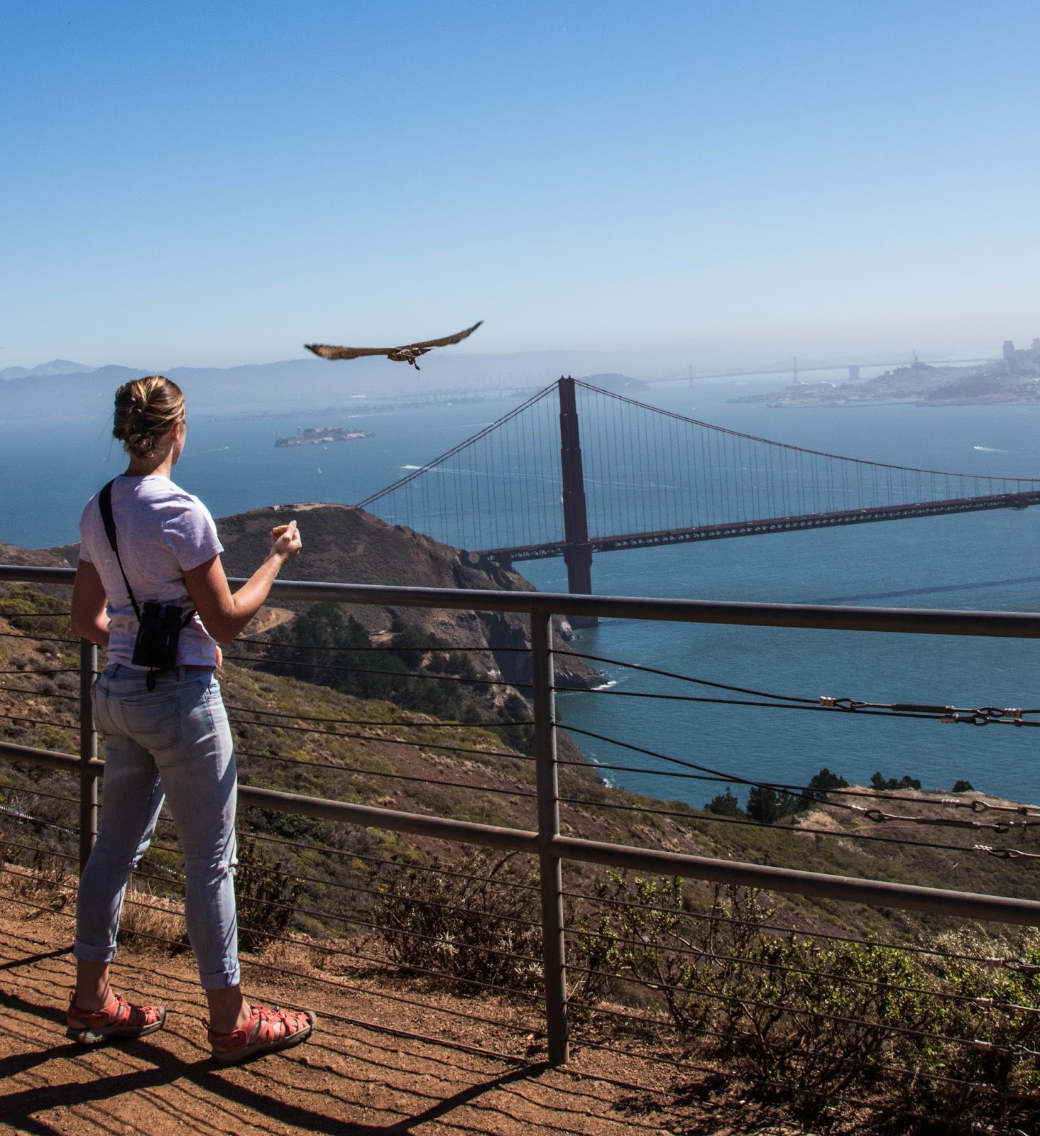
This morning, everyone met at Bldg 1064 with bags packed and ready to hit the road. And "The Wait began." and continued, and continued. It wasn't until 12:45 that POAK blind reported being on the board; but it was a small bird. Then at 2 PM, POAK called, they had a juvenile Red-tailed Hawk for us. A little scurrying around, and the hawk was brought to the office so that Libby could apply the transmitter. Kris held the bird, who was then named "Gypsy", while Libby applied the transmitter to a central tail feather. Once it was glued in place, the only evidence of the new jewelry was a few inches of the antenna protruding beyond the tail.
While Libby was busy with Gypsy, the other two teams headed for their assigned high points. One team to Twin Peaks and the other to the San Pablo Ridge. Gypsy, with new transmitter attached, was taken up to Hawk Hill and released in front of the Hawkwatch. Just in time for the end of their day.
That evening Gypsy settled down near the Miwok Trail, and the teams went home to sleep in their own beds for, maybe, the last time for a while.
Monday, Sept. 28, 2015 continued
Mike's Last Day of Journey
I simply can not convey nor condense everything that Mike accomplished on this last day with Journey. I don't want to change Mike's words, so I will try to post some snippets to give you a sense of Mike's last day with a mission.
The story begins back on Double Peak on Monday morning. "This is called Chase Syndrome-- the anxiety that something up ahead is getting away from you -- and the only antidote is to have a nice, calm experienced Day Leader there to tell you either to sit tight or to take off while she sits tight and monitors the scene. So anyway, you know which way I twitched."
Mike then "drove up Sunrise Highway into the piney-woods community of Mount Laguna -- and found the High Point turnoff, perfectly described in the directions........ Then, at .3 mi. from the highway, as I approached a locked gate up a rise, my omni started beeping. I coasted backwards to the off-pavement parking area, disconnected stuff, grabbed stuff, connected stuff, and charged up toward the gate. I pulled on the padlock -- no luck -- and squeezed through, levelling my yagi in the same direction I'd been hearing the signal as I moved, and in the dip between roadway and scrub to the left I found my peak. And then it went quiet."
Trying to access another high point in order to pick up Journey's signal, Mike heads towards Monument Peak. Blocked by locked gates, he continues, "Yagi in the right hand now. I'm determined to take the bull by the horns, but where ARE the horns? Back to the gate. Holy Toledo, there's a Forest Service truck at the bottom of the dirt lot, 75 yards away. I holler 'Wait up?', but he doesn't hear me. I scream at the nonplussed elderly couple just out of their car on the left, 'Tell him to wait?' They do, and he seems to notice. He walks away from us,.....then gets ready to slip behind the wheel. At this point The Syndrome kicks in. Without thinking, I'm at a dead run, full tilt down the hill toward him, waving the yagi from side to side high over my head, hollering 'Wait! Wait!Wait! Well, he waited. He was very nice, deferential, and informative. His name was Chuck."
So Chuck gave Mike a couple of leads, and Mike continued his quest. Through fences and escorted back out, heading higher and higher in the quest for the golden signal. Then Mike meets Troy who is Captain at a Fire Station/Cleveland National Forest/ USDA. Mike lays out his mission and Troy offers to have one of his men go up and unlock a gate for him, plus gives him a padlock so that he can unlock the gate on his way out. And Mike succeeds on getting up to Monument Peak. Success to the Mountain, not to Journey.
"So, here's out best shot, Telemetry. What's out there? Hmm. We know exactly who's out there, but we can't find him. He's not reporting in. And that's the way it is, says Walter Cronkite in my mind's ear. I stay for two quarter-hour readings, then regretfully toodle back down, lock up, revisit Troy at Camp Ole to thank him and convey the 'Mission accomplished but without success' news, and call it a day."
"How I wish Bill could have stuck it out, and how I wish Phil and he and Libby and everybody were down here at the bottom of the state to experience this surge of fulfillment, kind of, at giving it your best shot and covering a lot of ground and coming back with a certain amount of data and a whole lot of percolating, hard-to-define satisfaction. Joy even, maybe."
"Journey made good time on his final US day -- we have proof of that -- and we can surely be confident that he was over the border before 2 PM. Good enough."
Posted by Lynn Jesus, Season Coordinator, GGRO Radio-telmetry Program
from Mike's Notes from Sept. 28, 2015
Monday, September 28, 2015
The Conclusion of Journey's California journey....
South to the Border!
But with Mike's location so close to the Border, it looked like there would only be a few bearings before Journey crossed the line into Mexico.......... Yes, those words were from yesterday's post. Well, that was not exactly how the story ended......
Yes, Mike headed back to Double Peak on Monday morning. But Journey did not come by. Mike surmised that those strong winds/updrafts late yesterday, might have moved Journey inland. So Mike redirected his efforts inland and headed for Laguna Mountain which was one of the last locations of two of the teams on Zoe and Marathon (two earlier Broadwings). North of the Mexican border, it has a long view into Mexico, and allowed cross bearings with other teams which pointed miles into Mexico.
Mike's omni antenna (roof mounted and non-directional) picked up beeps as Mike was trying to get up to Laguna Mountain, but a locked gate stopped his progress. He tried to hike up and around the gate but wasn't able to succeed. So, Mike drove around looking for a secondary location nearby.
Mike did not send any text messages, until the very end of the day. Tired from two long days of solo tracking, Mike was pulled over at a Starbucks trying to escape the 10 mph traffic on I-5. In reference to the beeps, Mike texted, "That was the only word Journey had for us today, but we know he's okay and over the border. Tell you the rest of my day, some other time......"
And so, Mike documented the end to Journey's journey from the Marin Headlands to the Mexican Border.
* * * * * * * * * * * * * *
Thank You to all of the trackers who participated in following Journey's journey: Libby, Maxine, Bill, Ken, Mike and my husband, David (who hates telemetry). Long hot days, pestering flies, endless traffic, cheap motels, hour after hour without a beep, beep, beep...... you have to be a little crazy to volunteer for this job! But what a great job you all did.
And Thank You to All of the Banders who tried to provide us with a Broad-winged Hawk, especially Wednesday II Banders, and Hawk Blind in particular. Was that you, Buzz????
Thanks for another great Broad-winged Hawk Tracking Season.
Lynn Jesus
GGRO Radio-telemetry Program, Season Coordinator
PHEW!
Sunday, September 27, 2015
Mike Tracks Solo
This morning, Mike began back at Saddleback Peak and Journey was there, waiting for him. Unfortunately, Mike had to wait an hour and a half for Journey to pop up. Mike reported that at 1015 he had a bearing of 50 degrees with the attenuator "ON"... which means that Journey was close! Mike sent out a text message which ended with, "Lovely as this music is, I'm leaving now for Elsinore." He was referring to Elsinore Peak which has been a critical highpoint for us during Broad-winged Hawk tracking. From that location you can track a bird along the Coastal Route (down through San Diego) or a bird taking the inland route (like Zoe and Marathon).
At 1405 (2:05 PM), Mike reported that he had arrived at Elsinore and had a weak signal with a steady bearing of 260 degrees.
At 1430 (2:30 PM) Mike reported that Journey had picked up speed and the bearing was 232 degrees. "He's pealing out, post-dawdle."
At 1445 (2:45 PM) Mike updated the text, "1445 222. Wind 15 steady from him to me" That was short hand for a bearing of 222 degrees with the wind 15 miles per hour coming from the west. Mike debated with himself, whether he could make it to a more southern highpoint before Journey went down, and he decided to stay put.
At 1500 (3:00) Mike reported a bearing of 207. "I don't see him crossing today, but by noon tomorrow prob."
At 1530 (3:30) another bearing from Elsinore of 181! Almost due south! "He's high, using west-slope updraft from these strong onshore winds, now 15 - 20.
Mike, the energizer bunny, not wanting to give up for the day, sent his next text message from Double Peak, just north of San Diego. No signal. "In honor of the eclipse, the entire top plaza of Double Peak was full of cameras, telescopes, and convivial people. Extra park personnel and mobs from the local college. Wonderful scene."
(Earlier in the day, Libby had offered to drive back down south if we thought it was worth it.....Such as if Journey was still dawdling along. But with Mike's location so close to the Border, it looked like there would only be a few bearings before Journey crossed the line into Mexico, so we did not send a team down)
So Mike, solo, will document the end to Journey's journey from the Marin Headlands to the Mexican Border.
Saturday, September 26, 2015
The Plan for the Day......
The three teams were spread out over the Santa Barbara to LA basin. Spread out so far, that the teams ended up in three different towns for the evening. Libby and Ken were up by Mt. Pinos and stayed near Lebec. Maxine and Mike drove from Figueroa Mt. towards LA and stayed in Camarillo. And Bill stayed...... somewhere????
Saturday morning, Bill and M & M met up, and Maxine switched to Bill's team. Mike headed up to Saddleback Peak, and Bill and Maxine headed inland and set up again, on Mt. Wilson. Surely Journey would fly by one of these three high locations.
Once again, Libby and Ken had difficulty picking up any clear signals. But Libby did record 2 possible bearings which came and went very quickly. We could call it "essence of beep"! How frustrating to be at almost 9,000 foot elevation and not hear a nice beep, beep, beep. The view is expansive, but that only satisfies for so long. Now, remember, Libby and Ken had driven down to Southern California yesterday morning, and now they would have to reverse direction and be back to the Bay Area by tonight because they each had events to attend on Sunday. So, unfortunately, a little past noon the team was back on the road headed north. Tracking Journey's journey would be left to the two remaining teams, Bill and Maxine, and Mike.
Mike, on Saddleback Peak, began picking up Journey's signal, very faint from the west. And for the next few hours, Mike recorded various bearings, indicating Journey was moving slowly eastward, but never moving past Saddleback Peak. In the afternoon, weird noises haunted Mike, who was having trouble picking up Journey's frequency. What was going on?
So, maybe Bill and Maxine were able to get cross-bearings on Journey. Nope! Bill and Maxine had a day of silence. That made two days of silence for Bill, who is a great tracker; but with no signal to track, it was very frustrating. After four days in the field, the exhausted team called me and told me they were exhausted and felt they had to end their effort. So, Bill and Maxine began to head northward, back to the Bay Area.
And then there was Mike, whom I affectionately call an Energizer Bunny. Indeed Mike kept going. He no longer had a signal from Journey, he no longer had support teams for cross-bearings, but he was determined to restart the following morning, back by Saddleback Peak.
Will Solo Mike be able to pick up traces of Journey, or had Journey really given everyone the slip. Stayed tuned........
Lynn Jesus
Season Coordinator for the Golden Gate Raptor Observatory's Radio-telemetry Program
Friday, Sept. 25, 2015
Early Friday morning, Mike and Maxine headed up to Black Mountain, on the east side of Hwy 101, near San Luis Obispo. And Bill headed back to Cuesta Ridge, just west of Hwy 101. The two teams believed that Journey was still north of Cuesta, but there was really no way of knowing once the bird flew into the Coastal Range. It may have settled down immediately, or it may have continued skimming through valleys.
Meanwhile, back in the Bay Area, Ken and Libby were heading out before dawn to rendezvous with Journey and the other two teams.
Bingo.....Mike and Maxine, on Black Mountain picked up Journey's bearing still to the north of Cuesta Ridge, just as planned. A while later, they picked up a second bearing, still north of Cuesta. Then silence. Bill on Cuesta was in perfect position to hear Journey fly by....... but that was not to happen. After both teams suffered through silence for more than an hour, they decided that surely Journey must have slipped by, so M & M were off to Figueroa Mt. and Bill planned to drive down from Cuesta Ridge, head south, and go to a highpoint, when someone has picked up the signal.
Since the teams no longer had the signal on Journey, Libby an Ken decided to head to Mt. Pinos, an uber highpoint which should pick up Journey as he flies south through Santa Barbara or up through the mountains. At least that was the plan. Libby and Ken picked up keys to the locked mountain access and remained all day.... with only three, brief, very faint beeps, which Libby was not sure were really Journey or simply extraneous noise.
Meanwhile, back on Figueroa Peak, M & M picked up Journey's signal, stll to the north and recorded multiple bearings. Journey decided to tease the team by first being to the north, then the SE, then back to the N, etc. Obviously Journey was close. But time passed, and it was almost 6 PM and Journey was still moving around. Will he ever settle down? Will the team come down off the mountain, or become a permanent fixture. As it turned out, it was after 10 PM when the team was able to get into a motel. What a long day this had been! But at least they were a team who knew they had the signal.
Oh, and Bill? What happened to Bill? Well, thinking that surely Journey would pick up speed, Bill was sent to Mt. Wilson (north of LA), and never heard a beep. So, neither the sure thing on Cuesta, or the possible.... became reality. Bill was truly a solo team. Not even Journey would join him or tease him with a single beep...beep...beep.
But, at least we knew where Journey had spent the evening, and could plan for tomorrow, Saturday, September 26.

Thursday, Sept. 24, 2015
Our Lean, Mean Flying Machine is off to break records. Bill from the road to Fremont Peak picked up Journey's signal in line with Mt. Madonna. So that means that Journey was hiding out somewhere in the ridge just south of San Jose on Wednesday night. Bill and Maxine took bearings until it was obvious that Journey was going to head down the Hwy 101 corridor to the west, and so they headed down to Cuesta Ridge to get ahead of Journey while Mike Hall would come down 101 behind them. As Mike was heading south, he picked up Journey's signal to the west of Hwy 101 in the mid-afternoon. The bearing then moved to the SW indicating that Journey was still moving. It was good knowing that Bill and Maxine were far ahead so that Journey could not sneak by their location. However from Cuesta Ridge, the team never picked up Journey's signal, so the teams were unsure exactly how far south Journey's flight had taken him..... but they knew that Journey was still north of their location. The plan for the following morning would put Bill back up on Cuesta Ridge and Mike and Maxine would head over to Black Mt. in order to pick up cross bearings on Journey in the morning.
Meanwhile, a third team was preparing to join the team on Friday morning. Ken's college class meant that the team could not leave Thursday night, but rather would have to leave before dawn to get down to San Luis Obispo before Journey woke up! What a long day that will be for the team!
Stay tuned to find out where Journey will pop up on Friday morning!
The JOURNEY Has Begun
Wednesday, Sept. 23, 2015
It was a Great Day in the Headlands today. The Hawkwatch counted more than 1,000 raptors, and the banders provided 2 Broad-winged Hawks..... well, they caught two Broadwings for us, but we could only accept one. And so, the journey with Journey (our "J" bird) began. Chris Briggs and Kris and Laura efficiently handled the retrieval of Journey from Hawk Blind (thanks banders) and application of the transmitter, while David and Lynn fought morning traffic.
Of the four Broad-winged Hawks we've already followed, Journey is the only one which was determined to continue its long distance migration after release. Libby and Maxine on Twin Peaks were kept busy all afternoon as Journey moved past their location..... somewhat slowly. Maybe there was an early afternoon stop or a lunch or pit stop, but it looked like Journey was going to remain in SF for the first nights' Roost. However, in the mid-afternoon their bearings started to swing to the east and then southward.
Bill, solo, was driver, and tracker, and communicator and recorder. In otherwords, Bill wore all of the hats available. Unfortunately, we are short on staff, so today Bill did it all. Tomorrow, Maxine will join Bill.
David and Lynn began at the release site, just below Hawk Hill in the parking area. Then they set up a position near Kirby Cove, where Journey took his first break from the flight path within the trees of the cove. Within a half hour he was again up and flying. While keeping track of Journey, David spotted Ferrug, and multiple Broadwings, Red-shouldered Hawks, plus bunches of little Sharp-shinned and Cooper's Hawks. When Journey flew over the Golden Gate, the team headed southward through San Francisco to try to get ahead of him. But, that wasn't Journey's plan. He zipped eastward and to the Bay side of Maxine and Libby. Oh, gee,..... we're headed to the west side. We pulled over and took a bearing and then followed that bearing towards downtown SF. We lost the signal, but looked up to see another Broadwing flying right overhead.... of course, it was not our Journey. While trying to regain the signal, we pulled off into a side street and looked for a parking place, only to find Bill had beat us to the spot. We headed on to the East Bay, with no further signals from Yerba Buena Island, or any East Bay highpoints.
Tomottow, Libby will be back to work, and Mike will be coming on. Mike will have to wear all of the hats.... Driver, Tracker, Commnicator and Recorded because he will be working solo.
If an experienced GGRO Tracker would like to join the effort..... Just let me know. But be quick, because by Sunday, we anticipate that Journey will be approaching the Mexican Border. Will Journey's adventure be delayed due to weather. Stayed tuned to hear more about this Journey.
End of Day, Sept 21, 2015
Well, banders gave it a good try and stayed out all day.... but No Bird for Us!
September 20 and 21, 2015
Well, a very hot weekend has now passed and it is Monday morning, Sept. 21. Wow, Hawkwatchers and Banders both came off the hill early, both Saturday and Sunday. Obviously, the Telemetry Team is still "waiting" for a Broadwing or Better. (Broad-winged Hawk, Swainson Hawk, Ferruginous Hawk or even a Rough-legged Hawk).
So, Now, on Monday morning, the weather is a little cooler and the winds should begin coming from more favorable directions. Not all of the weather sites agree as to what will happen right here on the coast, but 16 happy banders have headed up to the blinds.
I will re-post when we have our "J" (Journey) bird.
September 2015: Broadwing or Better "Wait" Begins
September 18, 2015
Well, I've spent a few days over at 1064 trying to get everything organized so that the Telemetry Team can follow another Broad-winged Hawk to the Mexican Border. Thanks to Maxine, Ron, Brian and Linda who helped sort through all of the equipment. So far, only a few Broadwings have been seen by Hawkwatch, but we know they will be coming in larger numbers very soon. We had some unexpected wet weather on Wednesday, but California needs every drop it can get, and it certainly should help the large fires to our North and East. (As a side subject, David was banding on Wednesday and picked up a female, Sharp-shinned Hawk which "smelled" smoky. He had everyone in the blind "smell" the bird..... that was a first!)
When we begin to actually track a bird, I will update the posts daily, so that you can keep up with the progress of our subject. Hopefully, we get a picture to post to this blog, too.
So, until I have more to post, so long. Oh, this will be the "J" bird, and I'm favoring "Journey" unless someone else can tempt me with an even better name.
Subscribe to:
Comments (Atom)