Still in Bodega!
The trackers were out in the stormy weather all weekend keeping track of Echo. He was active during breaks in the storm but did not make any major moves. He stayed in the same area north of Bodega Highway and west of Joy Road. Now that the skies have cleared and the wind has calmed down, perhaps Echo will leave the area.
Echo is in Bodega!
On Friday, the teams pinpointed Echo's location to Bodega Road near the town of Bodega. He was stationary due to the rain. Hopefully the weather will clear enough for him to move! Thanks to the trackers for keeping on the bird in such wet windy weather!
Echo moves further north!
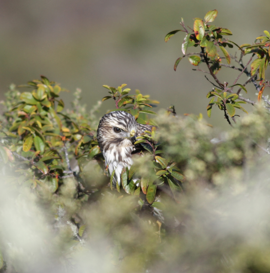
 The teams did not have great signals from Echo yesterday, but what beeps they did hear indicated that he was drifting slowly to the northwest, likely ending up somewhere near Occidental for the evening. Thanks to the teams for braving the terrible weather to track Echo! (Photo by Jim Garlock.)
A break in the storm allows Echo to fly!
Echo did not go very far upon his release on Tuesday afternoon - he
headed straight for the eucalyptus grove on Wolfback Ridge in the Marin
Headlands and settled in for the evening. However, at 9am on Wednesday,
the teams could not get his signal! It seems he had hunkered down to
wait out the storm. As the skies cleared just before noon, Echo popped
up and the teams were able to pick up his signal! He drifted slowly
north, ending the day west of Novato, near Stafford Lake. As the next
storm rolls in, the telemetry trackers are listening to see where Echo
goes next. His estimated locations will be added to the map here:
www.parksconservancy.org/radiotelemetry. Photo of intern Heather with Echo just before his release from Hawk Hill on
Tuesday afternoon. (Photo by Peter Sapienza.)

Late Season Tracking Begins!
"Echo" the juvenile male Red-tailed Hawk was caught in the Marin Headlands this afternoon! He was small but healthy, and released from Hawk Hill at 3:38 this afternoon. Hopefully he can get moving out of the area before the storms hit, but we will have to wait and see! Check back for updates and some photos.
Necropsy Summary
The final report did not add much to the preliminary results. Here is a summary of the final necropsy report:
On 9/29/2012 volunteers with the Golden Gate Raptor
Observatory trapped and radio-tagged Lakota, a juvenile Broad-winged Hawk in
the Marin Headlands. On 10/04/2012 she
was found dead on Angel Island by radio-tracking volunteers after several days
of limited movement. On 10/5/2012 she
was brought to the California Animal Health & Food Safety Lab at UC Davis
for a necropsy. Despite some
decomposition of Lakota’s body, the veterinarians provided some interesting
insight. First, Lakota had some muscle
atrophy in her breast muscles. This
suggests some nutritional stress which is not uncommon for birds during long-distance
migrations. Despite that condition, she
did have small fat deposits present, suggesting starvation was not imminent. Although the results were not conclusive, the
speculated cause of death was a 4-6mm hole in her back that pierced through the
muscles and ended in one of her lungs.
Blood around the wound indicates she was still alive at the time she was
punctured. No exit wound was present,
and no foreign debris was found in the wound, indicative that it was not caused
by a bullet or from a BB gun. The size
of the wound is consistent with a Red-tailed Hawk talon; however, we cannot rule
out other sources or predators.
October 5, 2012
Lakota was taken to UCD for necropsy, and initial results show that she had a small circular puncture wound near her vertebrae which extended into her lungs. No foreign object was found. While we will never know the exact cause of the injury, it may have been from a "natural" source.... another raptor.
I last saw Lakota, Sunday morning, rising up from Kirby Cove. She circled up from the groves of eucalyptus/pines/cypress and was so high in the sky that she became a little speck.... a true hawk dot. Although there were no other raptors in the sky, I hoped she would glide across the Gate and continue her southern movement. Unfortunately, that didn't happen, and her journey ended here, in the Bay Area.
I last saw Lakota, Sunday morning, rising up from Kirby Cove. She circled up from the groves of eucalyptus/pines/cypress and was so high in the sky that she became a little speck.... a true hawk dot. Although there were no other raptors in the sky, I hoped she would glide across the Gate and continue her southern movement. Unfortunately, that didn't happen, and her journey ended here, in the Bay Area.
Sad news...
We are very sorry to report that Lakota the juvenile
Broad-winged Hawk's body was found and retrieved from Angel Island this morning
by telemetrists. There were no visible signs of damage or cause of death. We
will have a necropsy done, but it may not tell us what happened. We all know that the weather has been
extremely hot along the coast, but that may or may not have contributed to her
death. She was banded, tagged, and released on Saturday. On Sunday, she was seen rising up from Kirby
Cove in the morning and flying high over Slacker Ridge. She was also
photographed flying in a kettle above Hawk Hill. She spent that evening in
Ayala Cove on the north side of Angel Island, with her signal picked up loud
and strong from the southern tip of Tiburon. The following day, her signal
moved to the south-east side of Angel Island. On Tuesday, only minimal movement
was detected, and on Wednesday, none. We will keep you posted about what we
find out. (Photo by Mary Malec of Lakota just after release on Saturday.)
A Change in the Weather
Today, Wednesday October 3rd, the heat finally gave way to fog so thick and wet that it sent the Hawkwatchers and Banders home. Despite the change in the weather, Lakota didn't moved from the south end of Angel Island. Tomorrow a team will go to see if they can figure out what's going on with her. Stay tuned...
-Lorri
-Lorri
Still Laying Low in the Heat
Tuesday, October 2nd, Lakota remained at Angel Island
James and David had bearings for most of the day from Lawrence Hall they came down later in the day and received some nice bearings from the Berkeley marina. Larry and Barb had no bearings on Twin Peaks . Lynn and Cheryl heard less than ten beeps all day, listening mostly to static.
Once Lakota gets across the gate or the bay, we anticipate 4 days of travel, so help is needed to extend the teams through the weekend.
Tomorrow Mike and Phil will be along the Berkeley
Perhaps the Hawkwatchers should perform a “wind dance” to rouse Lakota …
-Lorri
Oct 1 - Too hot to fly
Four teams were in the field ready to track Lakota's movement across the gate, but there was no breeze and no movement. Lakota's only movement was from north Angel Island to south Angel Island.
Teams in the field were Phil and Rich at Mt Hamilton, Larry and David at Twin Peaks, Barb and Lynn at Grizzly Peak and later Lawrence Hall of Science. Cheryl and James were chase team, "on the bird" on the Tiburon Peninsula. The best signal came from Mt Hamilton.
Tomorrow's teams are Cheryl and Lynn at Mt. Hamilton, James and David at Twin Peaks, Larry and Barb at Grizzly Peak.
Some of the telemetrists can't stay out for 7 straight days if Lakota continues to lay low in the heat, so if you're interested in joining a team towards the end of the week, please contact Lynn on her cell.
Some of the telemetrists can't stay out for 7 straight days if Lakota continues to lay low in the heat, so if you're interested in joining a team towards the end of the week, please contact Lynn on her cell.
I couldn't resist posting another photo of Sarah releasing Lakota, they're just so cute together. Aren't they?
-Lorri

Time to fly, Sarah releases Lakota on Saturday
Re-joining the Kettle
On Sunday, September 30th 2012, chase team Cheryl and Lynn started tracking Lakota from above her Kirby Cove roost site even before the hawkwatchers were in position on the hill. The other teams in place were James on Mt Hamilton and Phil with Richard on Grizzly Peak
Cheryl and Lynn could see a few roosting birds in the direction of their bearings towards Kirby Cove. Soon they saw a bird to their left, circling. It was a Broadwing hawk. Seen first at eye level, the bird increased in altitude as it circled, until Lynn Lynn Conzelman Road
Later in the day bearings were to the east, so the team headed to Twin Peaks in San Francisco Twin Peaks , Cheryl and Lynn met with literally busloads of tourists so once again they were docents of GGRO. They received bearings from Kirby Cove to Alcatraz , swinging back and forth multiple times. Signals were mostly circling and at times erratic. At that same time, hawkwatchers on the hill watched kettles form, move south towards San Francisco
At 1523 hours, the signal was lost from Twin Peaks . Phil and Richard, who had moved to Point Richmond, had a signal pointing toward Ayala Cove on Angel Island
How many new Broadwings arriving from the north will join the kettle? How many Broadwings will cross the gate tomorrow? Will Lakota be among them? Stay tuned!
-Lorri
 Lakota, seen by Hawkwatchers Sept 30

Lakota Day 1
Lakota, a juvenile broadwing, was trapped at Poison Oak blind at 1118 hours. She was released from the top of Hawk Hill at 14:30 and proceeded to fly 25 feet down the hill to a coyote bush, where everyone could see her! She stayed there for about an hour and a half, then flew to the north side of Hawk Hill and stayed there for about 15 minutes, then flew back to the east side of Hawk Hill. Lynn kept track of her there until approximately 1600 hours, then determined that she had moved down into Kirby Cove. David and Lynn took some bearings from either side of Kirby Cove, while James took a bearing from closer to the bridge back into Kirby Cove.
Lakota, a juvenile broadwing, was trapped at Poison Oak blind at 1118 hours. She was released from the top of Hawk Hill at 14:30 and proceeded to fly 25 feet down the hill to a coyote bush, where everyone could see her! She stayed there for about an hour and a half, then flew to the north side of Hawk Hill and stayed there for about 15 minutes, then flew back to the east side of Hawk Hill. Lynn kept track of her there until approximately 1600 hours, then determined that she had moved down into Kirby Cove. David and Lynn took some bearings from either side of Kirby Cove, while James took a bearing from closer to the bridge back into Kirby Cove.
The kettle of Broadwings (plus a couple of RTs, and several TVs) merged, split, re-merged, split for several hours. Allen pointed out to me two dark morph Broadwings that were part of the kettle. According to Lynn, none of the Broadwings seemed to cross and that included Lakota. The thermals seemed to evaporate over the gate, and then the kettle would return to Slacker Ridge or back towards Hawk Hill. It was an ever changing dance, and Lakota was having none of it.
This morning the fog has cleared and this might allow the BWs to cross, and that includes Lakota! Keep your bins up!
Telemetrists Phil and James will be out for the duration. Larry and Barb join in on Monday, as well as apprentices Richard and David. Lynn, who’s usually home base, just had to get back out there! So I will try to keep you all updated with the Lakota’s progress towards the border.
-Lorri
-Lorri

September 29, 2012
Well, we're back in the saddle, again. This morning the fog was hanging on Hawk Hill, but it was significantly lighter that Friday's Fogged Out day. We headed up Conzelman to beat the crush of birdwatchers (who wanted to see an amazing flight of Broadwings) and tourists who just wanted to see the City from a beautiful spot.
By 11 AM, Hawkwatch "officially" began the count as the sky cleared. I could "hear" the banders chatter on the radio. "Three Broadies between Slak and Poak". "How do we catch these things?" Eighteen minutes later, "POAK to Telemetry" comes across the radio. You've got to be kidding!!! Quick calls out to the team members (we're a skeleton crew today, but should be at max by Monday). Amazement was everyone's reaction. Will Telemetry ever recover from 2 Broad-winged Hawks within 2 weeks?!! We waited 18 years since Zoe, and now we've added Marathon and now Lakota. Wow!!
Okay, so maybe the fog kept Lakota from resuming her southern movement, but this won't last forever. Wait to see what happens tomorrow.
Oh, and by the way, I will be hitting the road, too. We were a little short handed today, so I packed a bag..... and since I have my bag packed, I might as well keep going. BUT, it will be hard to keep up the Blog while on the road. Maybe someone will help.........?

GGRO Intern Sarah prepares to release Lakota
Sept 21 -- An Unbelievable Day!
The luxury of having four teams out tracking is about to come to an end. Many of the trackers have been out since Monday and will be returning home today.
Two teams were placed along the peaks north of the LA Basin in order to pick up Marathon's signal as early as possible. The other two teams worked peaks and ridges to the south of where they believe Marathon was located.
Bingo! By 12:30, Marathon was clearly below the crest of the mountains and Mt. Wilson lost the signal. The two northernmost teams began their long journey home to Marin, Alameda and San Joaquin counties. Bill and Mike, on Elsinore Peak continued to record Marathon's movements while Phil and Linda were likewise busy on the San Jacinto Ridge. (These two locations were critical in determining Zoe's flight path). Marathon flew close enough to the San Jacinto Ridge that the team there was able to clearly hear her signal with the attenuator "On" (remember that little gadget which suppresses the signal so that only nearby signals are picked up). Phil and Linda decided to head down to Laguna Mountain, which is 20 miles north of the border with Mexico. Phil wanted to "hear" Marathon as she crossed the border. As they traveled on Hwys.79 and 371, they continued to pick up her signal. Unfortunately, Phil's car does not have air conditioning; therefore, Linda had to hold the receiver to her ear to hear the signal over the wind noise! And occasionally, they would pull over and take a bearing. But it all worked!
As Phil and Linda climbed up the road to Laguna Mt, the signal was crisp, clear and definitely "chirping" away. From approximately 3:45 to 5:45, they listened to the signal fade and return, first soaring then circling, back and forth. Phil said you could interpret Marathon's movements with such an active signal. Phil felt by the end of the day that Marathon was probably across the border. At the least, she was very close to the border; however, without a crossbearing we can't mark the time when she crossed.
It's been 18 years between Zoe and Marathon's flights were tracked by the GGRO Telemetry Teams. This year we had the luxury of being able to have 4 teams in the field for several days. In 1994, we only had 4 - 5 trackers out, in total. This year a total of 10 individuals were involved in tracking Marathon. There were some similarities, but there were also many differences in the flight paths of Zoe and Marathon, and they will be interesting to compare. Now we'll move into the data analysis phase. But no matter which path they took, in each case, there were 4 travel days between being banded and tagged in the Marin Headlands and crossing the border into Mexico. Marathon still has a marathon journey ahead of her.
Best wishes for a safe journey. We're going to head northward to sleep.
Sept 20 -- Crossing Mountains
What a day the trackers had today! Marathon was very elusive today. With four teams on high points, Marathon turned into the mountains, crossing the Carrizo Plains and heading to the eastern side of the Sierra Madre Range. The last bearing was from Frazier Peak and pointed in the direction of Santa Clarita (but, of course without a crossbearing we really don't know where to put a dot on the map).
The interactive map on the Parks Conservancy website is not able to keep up with the trackers. Or maybe, I should say that the trackers are so tired by the end of the day, that they have felt sleep was preferable to giving me points to put on a map. (When the teams return, we will be able to plot in detail and fill in the dots). Marathon is not making this job easy!
Marathon also seems to be a little behind Zoe's pace (BW, tracked in 1994). Some teams must end their tracking on Friday, but where will Zoe be? Will she be at the border by Friday night, as Zoe was, or will we be short teams on Saturday? A call has been placed for possible help needed for the weekend.

Sept 19 -- End of Day Summary
As you know we had teams spread out on high points, and it worked beautifully. The team on Williams Hill began picking up Marathon's signal around 1000, pointing back towards the Panoche Valley. At 1123 the team on Parkfield picked up her signal. By 1330, Marathon was passing Barb and Lorri on Williams Hill, and by 1530 she flew close to the team on Cuesta Ridge, above San Luis Obispo. (We have a little gadget on the receiver which allows us to restrict the signal strength so that we can tell if the bird is "close") By 1600 Bill, on Cuesta Ridge, and Phil and Mike on Parkfield Grade, all lost the signal abuptly. Did Marathon head into the mountains? Did she go down hunting? Did she head to roost? So many questions, but we'll have to be patient and see where she pops up Thursday morning.
Sept. 19 - New Interactive Map
Exciting news! We've got a interactive map which will show the rough estimation of Marathon's various locations, as she continues her journey southward. We will not be able to give more exact info until the teams (with their data logs) return home. Click here to check it out!
Sept. 19 -- Afternoon Report
The team on Williams Hill near Fort Hunter Liggett, and the team on Parkfield Grade both have the signal and report that Marathon is slowly (interesting word for a Broadwing who has so far to go) working her way south between the two teams. A third team is on Cuesta Ridge (above San Luis Obispo) waiting for her arrival.
Sept 18, Marathon Heads South from the Headlands
Marathon is her own girl, and is not following Zoe's lead from 18 years ago (East Bay, through Salinas Valley). Of course, maybe she's using Google Maps instead of the AAA maps which Zoe had to use.
Today, we were able to have 4 teams out on Marathon. Four teams is a bonus since we can have 2 teams on highpoints (in this case, Barb on San Bruno Mt and Cheryl on Mt. Hamilton) and two teams mobile. Phil and Mike began along the East Bay Ridgeline (Grizzly Peak area) and Bill and Lorri were "on the bird" early in the morning.
So, Tuesday morning Marathon woke up and continued her journey southward by heading over the Gate, through the City, and past Barb on San Bruno Mountain. Bill and Lorri were immediately playing catch up, but were able to get bearings as they also moved down the Peninsula. Meanwhile Phil and Mike had great bearings as Marathon moved southward towards Los Gatos. Add in the bearings from Mt. Hamilton, and I think we'll have a pretty good flight path for Marathon through the Bay Area.
Then Marathon flew into/through the Santa Cruz Mountains. Cheryl, on Mt. Hamilton, maintained the signal for most of the day...... hoorah! The 4th team was proving very valuable. The other teams repositioned to Fremont Peak and other nearby highpoints with mobile teams trying to get crossbearings. About 1500, crossbearings placed Marathon near Panoche Valley. One team traveling the area was unable to pick up her signal within the valley, so Marathon likely moved into the nearby hills. That was the last crossbearing of the day.
Similarly, when the teams were tracking Zoe in 1994, they would lose her mid-afternoon and then the following morning she would pop up about 40 miles south. Where will Marathon pop up on Wednesday? We'll all have to wait and see.
Sept. 17, 2012: On Your Mark, Get Set,.........Go!
The 2012 tracking season has begun with Marathon, a juvenile Broad-winged Hawk. It's been 18 long years since we tracked our first Broadwing, Zoe. When told that we have a Broadwing, Phil Capitolo simply said, "I'm stunned!" That elusive Broadwing that we've been waiting for, flew into Hill 88 blind, and was banded by Dick Horn.... on his birthday! Thank You, Dick for sharing your present.
Soon we'll have a couple of photos to add to this Blog, so stay tuned for daily updates (or as frequently as I can get them posted).
After being released from the road beneath Hawk Hill, Marathon flew directly over Slacker Ridge and settled down on the East side of the ridge, overlooking the North Tower of the Golden Gate Bridge, and Hwy 101. Tomorrow we anticipate that she will continue her southward journey. Stay Tuned!
Update on Diana and Coco
Coco:
February 2, 2012! Coco is located on the ridgeline just west of Lower Crystal Springs Reservoir, just north of Highway 92 and west of Highway 280. It is very surprising that his transmitter is still working, since the manufacturer gives the battery a 6 - 8 week estimated life and we're going on 3 months! Coco is active, up and circling and apparently hanging out with a number of other Redtails along the coastal ridge.
Diana:
Jan. 3, 2012! Phil walked into the Laguna de Santa Rosa and observed Diana perched in a tree. Her transmitter was still working (almost 2 months after release). Phil returned on January 17, but was unable to pick up her signal. At the end of January, Phil and Lorri checked out the wider region, but were unable to pick up her signal. Her transmitter may have stopped transmitting, or she may have moved beyond the region.
Subscribe to:
Posts (Atom)